20K Distance
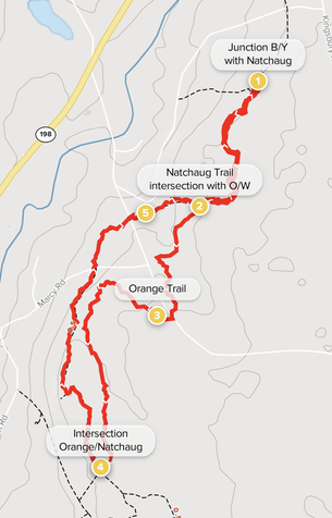
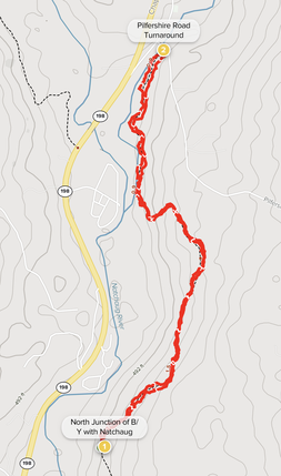
The 20K course utilizes the 10K core route with the addition of both a southern leg of 4.3 miles and northern leg of 3.2 miles.
Begin by going right (south) on the CCC Trail (Blue/Yellow) with a nice stretch along the Natchaug River and some challenging climbs. Continue to follow the CCC Trail as it crosses a forest road at approx. 1.0 miles and proceed another .5 miles up to the intersection with the Blue blazed Natchaug Trail, turn right on the Natchaug Trail. After approx. .6 miles on the Natchaug Trail take a left on the Orange/White blazed trail. After crossing Morey Road bear right on the Orange Trail which intersects with the Blue blazed Natchaug Trail at some old foundations after approx. 1.7 miles. Turn right (north) on the Natchaug Trail crossing Orchard Hill and Marcy and Morey Roads (a good site for a drop bag of fluids/nourishment), go past the waterfall and Orange/White Trail intersection following the Trail back to the south junction with the CCC Trail (B/Y blazed). Continue on the Natchaug Trail as the 10K route past Beaverdam Pond and the General Lyons Memorial (a good site to cache a drop bag of fluids and nourishment). At the north junction with the CCC Trail continue north on the single track Natchaug Trail for another approx. 1.6 miles to the turnaround at Pilfershire Road (another good site for a drop bag). Proceed back on the Natchaug Trail to the junction with CCC Trail (B/Y) turning right on the CCC Trail and follow down the hill, along an old forest road, and then right onto a single-track trail along the Natchaug River to complete the loop to the Finish.
|
20K Mileage – approximately
Start to: 1.5 miles to junction of CCC Trail (Blue/Yellow blazed) with Natchaug Trail (Blue blazed) – South on Natachaug 2.1 miles to Orange/White blazed trail 3.8 miles to Natchaug Trail (Blue blazed) at old foundation and kiosk 5.8 miles to south junction with CCC Trail (Blue/Yellow blazed) 6.9 miles to Beaverdam Pond 7.8 miles to General Lyons Memorial 8.5 miles to north junction with CCC Trail (B/Y) 10.1 miles to Pilfershire Road turnaround 11.7 miles to north junction with CCC Trail (B/Y) 13.3 miles to Finish. |
20K COURSE – SOUTHERN LEG
Waypoints 1. South Junction of Blue/Yellow with Natchaug 2. Orange/White Junction with Natchaug Trail 3. Orange Trail 4. Orange Junction with Natchaug Trail 5. Goodwin Cascade AllTrails Map Link: Goodwin-Forest-20k-south-leg Click the ⋯ to download Map to Phone 20K COURSE – NORTHERN LEG 1. North Junction of B/Y with Natchaug 2. Turnaround at Pilfershire Road 1. North Junction of B/Y with Natchaug AllTrails Map Link: Goodwin-Forest-20k-northern-leg Click the ⋯ to download Map to Phone. |


